


Renato1
Established Member
- Joined
- May 1, 2015
- Posts
- 1,730
I was trying to find a map of Coronavirus hotspots in Victoria on Google, and found nothing.
Wouldn't it be nice to know if one is in a hotspot, or where those hotspots are so as to avoid them?
I know they exist because there are news reports of possible government action at hotspots.
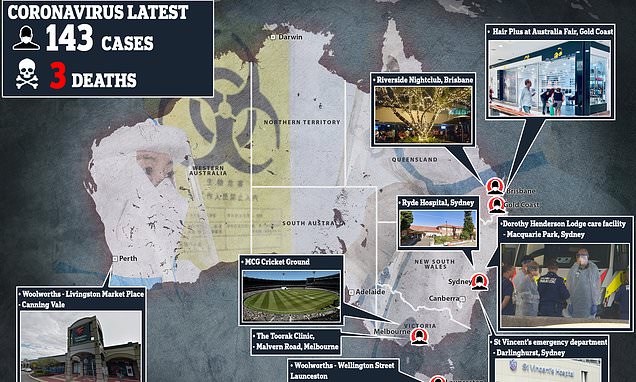
However, I did find a limited map of Australian hotspots in the Daily Mail UK - Australia - which seems to publish stuff Australian papers don't.
 www.dailymail.co.uk
Has anybody else located a more detailed map of suburban hotspots?
Regards,
Renato
Wouldn't it be nice to know if one is in a hotspot, or where those hotspots are so as to avoid them?
I know they exist because there are news reports of possible government action at hotspots.
However, I did find a limited map of Australian hotspots in the Daily Mail UK - Australia - which seems to publish stuff Australian papers don't.
Horrifying map shows Australia's coronavirus hotspots
There are at least 141 confirmed cases of COVID-19 in Australia, with most patients contracting the deadly virus after returning from overseas travel.
Has anybody else located a more detailed map of suburban hotspots?
Regards,
Renato