You are using an out of date browser. It may not display this or other websites correctly.
You should upgrade or use an alternative browser.
You should upgrade or use an alternative browser.
Help with Longitude and Latitude from iPhone photo
- Thread starter VPS
- Start date
- Status
- Not open for further replies.
Solution
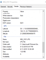
If anyone can help me translate I'd very grateful
Do you mean understand the format given? If so, 35, 1, 15.63 is 35 degrees, 1 minute, 15.63 seconds south and 138, 31, 23.77 is same D,M, S east for longitude.
Grovelling apologies if that's not what you meant!
Ikara
Active Member
- Joined
- Jun 18, 2006
- Posts
- 509
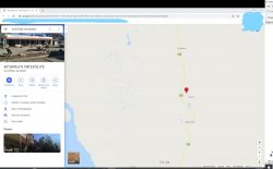
I didn't fine tune it, but Google Earth has the co-ordinates somewhere down near South Brighton.I am going around in circles trying to find work out where some photos were taken. This one should be a cafe somewhere around Glenelg in SA.
If anyone can help me translate I'd very grateful
View attachment 218761
JB
RooFlyer
Veteran Member
- Joined
- Nov 12, 2012
- Posts
- 31,328
- Qantas
- Platinum
- Virgin
- Platinum
- Star Alliance
- Gold
If anyone can help me translate I'd very grateful
Do you mean understand the format given? If so, 35, 1, 15.63 is 35 degrees, 1 minute, 15.63 seconds south and 138, 31, 23.77 is same D,M, S east for longitude.
Grovelling apologies if that's not what you meant!
VPS
Enthusiast
- Joined
- Apr 2, 2011
- Posts
- 10,553
- Qantas
- LT Gold
- Virgin
- Gold
Do you mean understand the format given? If so, 35, 1, 15.63 is 35 degrees, 1 minute, 15.63 seconds south and 138, 31, 23.77 is same D,M, S east for longitude.
Grovelling apologies if that's not what you meant!
That is exactly what I meant - THANK YOU
VPS
Enthusiast
- Joined
- Apr 2, 2011
- Posts
- 10,553
- Qantas
- LT Gold
- Virgin
- Gold
Elevate your business spending to first-class rewards! Sign up today with code AFF10 and process over $10,000 in business expenses within your first 30 days to unlock 10,000 Bonus PayRewards Points.
Join 30,000+ savvy business owners who:
✅ Pay suppliers who don’t accept Amex
✅ Max out credit card rewards—even on government payments
✅ Earn & transfer PayRewards Points to 10+ airline & hotel partners
Start earning today!
- Pay suppliers who don’t take Amex
- Max out credit card rewards—even on government payments
- Earn & Transfer PayRewards Points to 8+ top airline & hotel partners
AFF Supporters can remove this and all advertisements
RooFlyer
Veteran Member
- Joined
- Nov 12, 2012
- Posts
- 31,328
- Qantas
- Platinum
- Virgin
- Platinum
- Star Alliance
- Gold
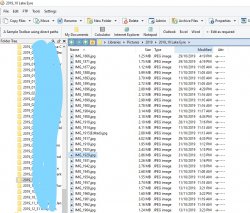
Directory Opus
Is that the camera program? Sony has one which brings your pics up on Google maps - actually in 3D- they 'point' the right way!
RooFlyer
Veteran Member
- Joined
- Nov 12, 2012
- Posts
- 31,328
- Qantas
- Platinum
- Virgin
- Platinum
- Star Alliance
- Gold
What I found out when I looked at my own iPics is that the lats are positive numbers in both the northern and southern hemisphere, which is odd. The repeated zeros in the middle of the long decimal minutes in VPS's example are always either repeated zeros or nines, and then the end digits differ. So the end digits seem to mean something different, not just the end of the 'decimal minutes' number.
Here's one in New York:

Here's one near my place:

Anyone understand the 0s, 9s and the end numbers? And how does it tell northern from southern hemisphere?
Here's one in New York:

Here's one near my place:

Anyone understand the 0s, 9s and the end numbers? And how does it tell northern from southern hemisphere?
VPS
Enthusiast
- Joined
- Apr 2, 2011
- Posts
- 10,553
- Qantas
- LT Gold
- Virgin
- Gold
Is that the camera program? Sony has one which brings your pics up on Google maps - actually in 3D- they 'point' the right way!
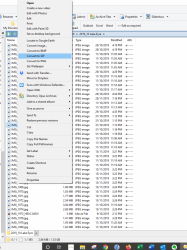
No it's a commercial program that I bought that I use all the time. It's great for reducing the size of photos and renumbering. There are a heap of features that I don't even know how to use
So you find the photo and then right click Locate on Google - it says Google earth but I changed it so it's Google


Post automatically merged:
What I found out when I looked at my own iPics is that the lats are positive numbers in both the northern and southern hemisphere, which is odd. The repeated zeros in the middle of the long decimal minutes in VPS's example are always either repeated zeros or nines, and then the end digits differ. So the end digits seem to mean something different, not just the end of the 'decimal minutes' number.
Here's one in New York:
View attachment 218924
Here's one near my place:
View attachment 218925
Anyone understand the 0s, 9s and the end numbers? And how does it tell northern from southern hemisphere?
And I'd be interested to know that as well
- Status
- Not open for further replies.
Become an AFF member!
Join Australian Frequent Flyer (AFF) for free and unlock insider tips, exclusive deals, and global meetups with 65,000+ frequent flyers.AFF members can also access our Frequent Flyer Training courses, and upgrade to Fast-track your way to expert traveller status and unlock even more exclusive discounts!

AFF forum abbreviations
Wondering about Y, J or any of the other abbreviations used on our forum?Check out our guide to common AFF acronyms & abbreviations.
Currently Active Users
- Noah Count
- HealthyPotato
- Flying Fox
- TeaKozy
- Dmac59
- Keasm
- kaceybutler
- cgichard
- group-of-5
- Battymum
- kamchatsky
- PERLHR
- kpc
- am0985
- AdamHal
- Beer_budget
- dcg
- streety
- RB001
- GarrettM
- oobi doobi
- Daver6
- moa999
- Growing Older
- woolton
- goldenhorn
- Blackswan
- ShelleyB
- darloflyer
- VPS
- Buzzard
- axkhanna1
- #flying
- Stephanie Logan
- Sbv72
- fairbasa
- SomeRando
- Superhappykid
- ma1tr!x
- NoName
- FF98
- Oraia
- sykoticx
- SydneySwan
- pauldab
- sleepingpandarino
- Leroy
- untoldhero
- craven morehead
- oz_boater
Total: 1,371 (members: 84, guests: 1,287)


