The 5 Stans of the Silk Road

Status
Not open for further replies.
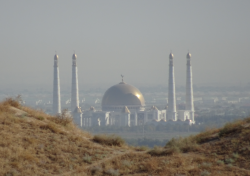
Next stop, the National History Museum. An enormous building, but only a small portion is for public displays. The view out from the front:

IMG_4275.JPG

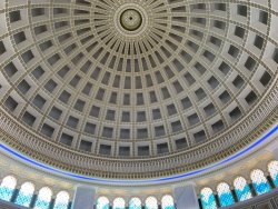
The central hall. Red granite columns and floors - made a bit of a break from polished marble.

IMG_4321.JPG

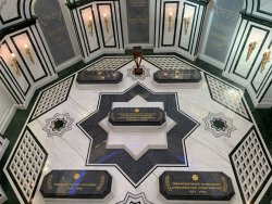
We were shown around by a guide, whose English was very hard to follow. But this I think is the world's biggest carpet ... with the current President shown at the front

IMG_4278.JPG

Now, (for once) I won't attempt to explain the history of the region ... incredibly complex, and needless to say, incredibly old.

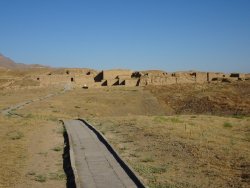
Just outside Ashgabat is the ruins of 'Old' Nisa, the capital of the Parthians and which flourished about 250BC to about 150AD. It was destroyed by an early earthquake. We visit the site tomorrow, but the best relics we saw in the museum came from there.

Most notably, some gorgeous ivory rhytons - or wine drinking vessels. Apparently they found ?hundreds of large wine holding vessels and dozens of these rhytons, so the culture sounds well lubricated. These are all from the 2nd century BC

IMG_4290.JPG

IMG_4291.JPG

IMG_4293.JPG

IMG_4289.JPG

IMG_4296.JPG

IMG_4299.JPG


When we exited, there was a changing of the guard ceremony, which was a bit far away, but good goose-stepping viewing (off to the left).

IMG_4327.JPG
 
Mid afternoon and our local tour leader decided we should try for the cable car again. And we were successful - no road blocks.

its quite a long ride, and goes from 200m at the base to about 1300m at the top, about 1/3 the way up the range. The top of the cable car is in the 'no mans land' between Iran and Turkmenistan - you pass over barbed wire fences etc along the way.. The border is along the crest of the range behind. Cost was the equivalent of US$1.50.

We go over several undulating hill-tops on the way up:

IMG_4333.JPG

IMG_4335.JPG

The lookout at the top. Very expensive ice-creams!!

DSC03833.JPG

Panorama from the top:

1566202289825.png

A few zooms into the city of marble:

DSC03843.JPG

'Olympic' Stadium:


DSC03840.JPG

DSC03838.JPG

The no-mans land fence (the border is a number of miles up the mountain.

DSC03829.JPG
 
Our local guide took us to a 'great BBQ place' which had a great vibe:

IMG_4342.JPG

IMG_4347.JPG

Unfortunately on my table 2 out of 4 orders were forgotten, then the wrong ones brought and at the end we were still missing one item. Can happen anywhere. The beer was good though!!

Random buildings we passed on the way back to the hotel:

IMG_4365.JPG

IMG_4368.JPG

IMG_4369.JPG

IMG_4371.JPG

IMG_4373.JPG

IMG_4382.JPG
 
The Frequent Flyer Concierge team takes the hard work out of finding reward seat availability. Using their expert knowledge and specialised tools, they'll help you book a great trip that maximises the value for your points.

AFF Supporters can remove this and all advertisements

Day 3 in Ashgabat and I'll post the following out of order, as i want to show them before we leave town in an hour or so and lose internet.

At 3 pm we hit the road in 5 4WD for the Darvaza crater, otherwise known as the 'Door to Hell'. Its an absolute trip highlight for me.

After an hour we were well out of 'civilization' and on a dual highway, but this is really only 2 bitumen strips and cars going both ways mostly use the one side. The other side is occasionally incomplete, which seems really odd in a country where so much is spent on marble buildings in th capital.

Grasses gave way to a sandy desert landscape. Occasional cars - the highway has reasonable use. It connects the capital with the north-west of the country, through its middle.

IMG_4459.JPG

Meh. Compulsory camel shot.

IMG_4461.JPG

Two strips of rad, most cars on one side!

IMG_4464.JPG

After two hours, travelling at 120-130 km/hr once out of town (national speed limit 90 km/hr) we had a pit stop at a 'road house'.

IMG_4472.JPG

Definitely in the desert

IMG_4469.JPG


WHAAAT!!! IS THAT IT??? :mad:

IMG_4476.JPG

IMG_4478.JPG

Ah ... just an amuse bouche. a bit more driving.

IMG_4483.JPG

After another hour or so after the roadhouse, the main event ... but the show starts at sunset :)

IMG_4485.JPG
 
First there was dinner at a camp nearby. By this time it was cooling down a bit and a slight breeze, so very pleasant.

IMG_4506.JPG

Especially with cold Birks beer (US$5/bottle)

IMG_4500.JPG

A couple of reprobates in the desert - no wine, so what can you do?

IMG_4502.JPG
Vege soup, fresh cooked tandoor bread and roast chicken. All appreciated by everybody.

IMG_4504.JPG

IMG_4507.JPG

our chefs ....

IMG_4510.JPG


IMG_4512.JPG

Then, as the sun set .... SHOWTIME!!! ... and I have to go to breakfast, so hang on.
 
The Darvaza Fire Crater: Amazing, breathtaking, unique, surprising, HOT!

The radiated heat is enough, but the swirling wind and fore induced wind causes blasts of air like you open an oven to hit you ... but unlike an oven, it keeps coming until you turn away and step some paces back. The noise is moderate - like a blasting gas jet, which of course is exactly what it is, tomes a thousand!

About 40 years ago, Soviets were drilling for gas here, and the porous rock started caving in on itself. Gas was escaping, so they lit it to flare it off. 40 or so years ago, its still buring and falling in on itself.

its 69m x 30m.

DSC04006.JPG

DSC04008.JPG

DSC04004.JPG

DSC04011.JPG

DSC04012.JPG

In spite of @juddles concerns, there were no sacrifices this night!!

DSC04016.JPG
 
When I was 27, I took a tour up "Mount Olimpus" in Turkey, which was also leaking lit gas. And quite spectacular in the sunset and after. Of course, I did not at the time have a camera capable of capturing it, but we did enjoy our tour.
 
A few more pics. Am now in rural Turkmenistan (Mary), so wifi is a bit creaky.

IMG_4523.JPG

IMG_4525.JPG

After an hour or so viewing at the crater, we headed back, leaving at about 8:45pm for the 3.5 hour drive back. Zooming through the Turkmenistan desert at night at 120-135 km.hr was an experience!! Just hoped we wouldn't hit any camels! We did see a fox.

IMG_4540.JPG

IMG_4552.PNG
 
In the morning of the day we went to the crater, first stop was Nisa, just out of Ashgabat. Its a rather poorly preserved, mostly mud brick built 'city', capital of the Parthian empire from about 250 BC to 210 AD. But the rhytons that I showed previously came from here, together with some other nice artifacts.

1566304084085.png

The Parthians defeated the Roman legions to the west of present day Turkmenistan, and the Turkmen took them as slaves. The Romans introduced arches to the local architecture, and this is a surviving original.

1566304635264.png

A nearby large and new mosque, seen through the ramparts of the Nisa complex. We go there next.

1566305366804.png
 

Attachments

  • DSC03860.JPG
    DSC03860.JPG
    190 KB · Views: 3
  • 1566304902959.png
    1566304902959.png
    1.1 MB · Views: 4
@RooFlyer what app are you using for map position? I'm particularly interested that it shows Lat/Long.

maps.me

You can download very detailed maps onto your phone and use them as GPS maps while off line. Can download countries, or regions of countries you are travelling to, then delete them when done with, if needs be.
 
Next to the mosque is the mausoleum of the Turkmanbashi. Photographs of the front guards tolerated from afar:

DSC03879.JPG

1566347493807.png

The mosque next door was built about 10 years ago, and can hold 10,000, but is rarely used to any extent, as its well out of town

1566347900567.png

Inside is very beautiful, with a wonderful lush carpet underfoot.

1566348177191.png

1566348501127.png

1566348809878.png
 

Attachments

  • IMG_4416.JPG
    IMG_4416.JPG
    312.3 KB · Views: 0
  • IMG_4421.JPG
    IMG_4421.JPG
    288.1 KB · Views: 0
As JohnM noted up-thread, the form of Islam practiced here is pretty laid back. Pork available in restaurants, no veils, western dressing females (when not traditional), loud calls to prayer forbidden pre dawn ... you'd be hard pressed to guess that it is an 'islamic' country.

Random shot from the bus.

1566349257461.png

Then off to another mosque. this one smaller, less ostentatious, and apparently more popular with the locals.

1566349653979.png

1566349824820.png

I love the geometry you get in these places ...

1566350067988.png
 
So, a new day and we head to Mary, to the south-east, and base to explore the ancient city of Merv, UNESCO World Heritage.

There has been a settlement here for about 4,000 years, but ancient Merv was settled about 5th or 6th centuries BC. Many religions lived together in harmony here. It had a lot of history until the din of Gengis Khan arrived in about 1221, captured the city and killed everyone - estimated between 300,000 and 500,000 people.

The most notable surviving structure is the Great Kyz Kala, of uncertain function. A magnificent survivor from the 7th century , with unique corrugated walls of mud brick.

7C39A7A3-9275-4389-9E6B-677EFCDFA847.jpeg

D44BF31B-96C3-4F55-B67A-BD47AC20CB99.jpeg

05F03530-883E-4B6F-9FB3-635F1B1FC796.jpeg

We meet some lovely local ladies who showed us to take some photos.

83695DC3-48FC-4FDB-A612-B0978D2BC9B9.jpeg
 
Sponsored Post

Struggling to use your Frequent Flyer Points?

Frequent Flyer Concierge takes the hard work out of finding award availability and redeeming your frequent flyer or credit card points for flights.

Using their expert knowledge and specialised tools, the Frequent Flyer Concierge team at Frequent Flyer Concierge will help you book a great trip that maximises the value for your points.

Oops a bit out of order.

On the drive down to Mary, on a divided Highway, we had the mountains to the Iranian not on it right, and flat cotton fields on the left ( with flood type irrigation). The Russians introduced cotton here, which of course consumes vast amounts of water in this desert country. It comes from the rivers flowing from Tajikistan.

4A8A0F86-48EF-4CAE-ADFE-A53F7FDF0953.jpeg

A quick stop at Abiwert, a 8th to 10th century town of mud brick. Not much left today.

DEBF233A-2589-4B9E-BD81-CDFAFDB55BB1.jpeg
 
Status
Not open for further replies.
Back
Top