New Zealand - North South and the bit in between - 2014

Status
Not open for further replies.
Finishing off Hokitika.

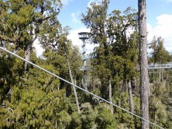
Just 15 mins south of the town is the "West Coast Tree Top" walk. It was built by the same company that built the treetop walk in 'The Valley of the Giants' in south west W.A.. This one runs at about 20 metres high through a "Rimu and Kamahi tree canopy"

Hoki35.jpg

Hoki34.jpg

It can be a bit daunting for those with a fear of heights - like me. You can see how relaxed I am in this photo. My hands were never far from a rail and there were several bits that I avoided.

Hoki33.jpg

Climbing up this tower is something I did avoid - unlike my wife.

Hok13.jpg

There was a separate gate to go out onto a cantilevered section which can get up a nice sway. Needless to say, only one of our group went on it.

Hoki38.jpg

There was, apparently, a nice view over the nearby Lake Mahinapua.

Hoki40.jpg

One last view of the west coast beaches. My wife picked up a few little pieces of greenstone on the beach.

Hoki32.jpg

And now off to what you have been waiting for - the mountains

Hoki37.jpg
 

Attachments

  • Hoki36.jpg
    Hoki36.jpg
    344.8 KB · Views: 0
Last edited:
My wife has complained about what I said in regards to Greenstone jewellery. She actually did buy some but it was from an "Antique" shop in Nelson. She bought a bangle and I bought some "Pick of Punch" books from the1960/70's.

Jewel.jpg

Punch.jpg
 
Sponsored Post

Struggling to use your Frequent Flyer Points?

Frequent Flyer Concierge takes the hard work out of finding award availability and redeeming your frequent flyer or credit card points for flights.

Using their expert knowledge and specialised tools, the Frequent Flyer Concierge team at Frequent Flyer Concierge will help you book a great trip that maximises the value for your points.

The road to the mountains was not always straight and easy.

Holi27.jpg

Our first stop

Glac1.jpg

The access road alongside a meltwater stream.

Glac2.jpg

A scenic view from the car park

Glac9.jpg

There was a long walk over the moraine valley

Glac6.jpg

Looking back down the valley.

Glac3.jpg

At the foot of the glacier. Note the warning signs. Two Australians had been killed in a ice fall at the foot of this glacer in 2009.

Glac4.jpg

Glac7.jpg

Glac10.jpg

Some blue ice

Glac8.jpg
 
We stopped overnight in the little town of Fox Glacier.

The view from the front of our motel was pretty nice.

Glac21.jpg

Glac27.jpg

We then took a short drive to Lake Matheson - it"is famous for its reflected views of Aoraki / Mount Cook and Mount Tasman". And we soon saw why.

Glac28.jpg

Glac22.jpg

Some fooling around with the camera settings.

Glac25.jpg

These were taken from "Reflection Island".

A few people in front of me.

Glac23.jpg

My turn. I believe that it is Mt Tasman on the left and Mt Cook is the pointed peak to the right - but I am not 100% sure.

Glac24.jpg

Glac29.jpg

I think I got the peak of Mt Tasman through the clouds.

Glac30.jpg c
 

Attachments

  • Glac28.jpg
    Glac28.jpg
    179.5 KB · Views: 0
The next day we went to Fox Glacier. This was a much harder walk than at Franz Joseph and the glacier itself seems to have retreated more up the hill.

There was a bit of creek hopping.

Glac41.jpg

Glac50.jpg

Plenty of warning signs as you walk up the valley.

Glac49.jpg

The valley also seemed a lot more desolate than at Franz Joseph.On the way up I had to ignore the sign and stop to get my breath at a couple off points. It was a pretty tiring climb.

Glac48.jpg

Glac45.jpg

If the rocks don't get you the ice will.

Glac46.jpg

You could not see too much of the glacier from the lookout point.

Glac44.jpg

This B & W shot I took seems to show the ruggedness of this place better.

Glac51.jpg

A nice spot for a cooling dip.

Glac47.jpg
 
Now we set off to Wanaka going via the Haast Highway over the Haast Pass.

The road ran alongside the ocean for a while.

Knights Point

Wan1.jpg

The black spots on the beach are seals.

Wan7.jpg

It then runs alongside the Haast River for a fair while. There was plenty of evidence of rockfalls on the road.

Wan11.jpg

We had a bit of delay at this spot. You can see by the running water , how difficult it must be to keep these roads clear of landslides etc.

Wan3.jpg

We stopped to have a look at Thunder Falls which feeds into the Haast River.

Wan2.jpg

There are no prizes for guessing the origin of this beautifully coloured water.

Wan12.jpg

You also pass through some lovely alpine valleys.

Wan4.jpg

The road then began to pass alongside some beautiful lakes.

Wan13.jpg

Wan14.jpg

This is Lake Hawea

Wan8.jpg
 
Around and about Wanaka and especially Lake Wanaka. Like many of these small towns at beauty spots in NZ the town itself is not very photogenic.

Our self contained accommodation in Wanaka - run by a Swiss couple who had been professional skiers.

Wan15.jpg

Wan17.jpg

The view from the garden

Wan16.jpg

It was just a short walk to the shores of Lake Wanaka

Looking out over the lake from Bremner Bay

Wan18.jpg

Wan19.jpg

The jetties on the town beach

Wan20.jpg

Looking back at Wanaka town from the other side of the lake.

Wan21.jpg

Looking across the lake directly towards Bremner Bay. I took the earlier photos just to the left of that large crop of trees on the far shore.

Wan22.jpg

A small holiday shack on the shores of the lake

Wan23.jpg

Further north on the lake - I think.

Wan6.jpg
 
After Wanaka we headed south to Te Anau via Queenstown.

We took the Cardrona Valley Road. It is only open during the summer months. This meant we had some spectacular views on the drive, especially as Queenstown came into sight.


T6.jpg

T14.jpg

T5.jpg

T10.jpg

Lining up on runway 05/23. It must be an 'interesting landing/takeoff.

T7.jpg

T13.jpg

The road down into the valley reminded me of some of the alpine regions in Europe.

T9.jpg


T2.jpg

We had a quick look at the historic gold mining town of Arrowtown. It was crowded with tour bus passengers, far more so than it looks in this photo. So we spent a pleasant half an hour at the Arrowtown Primary School fete and bought some cakes and toffee.

T8.jpg
 

Attachments

  • T11.jpg
    T11.jpg
    169.1 KB · Views: 1
Queenstown was covered in low dark clouds with rain showers and strong winds so we only had a quick look around before moving off.

The road runs alongside Lake Wakatipu for quite a distance and gives some good views even under dark skies.

T20.jpg

T26.jpg

The highlight of downtown Te Anau was this "map" of the local area.

T21.jpg

Looking across Lake Te Anau towards the town of Te Anau.

T22.jpg

I didn't often take photos of meals in these pre-AFF days. However, I hadn't seen Ice Cream in cardboard wrapping like this for umpteen years so I had to buy it. (We had a freezer in our motel room.) It was actually very nice.

T23.jpg

We woke up on the day of our departure to see a fresh snowfall on the mountains. The name of our Motel was justified on this day. If you compare this photo to the earlier twilight one you can see the difference . This was the 11th of November.

T25.jpg
 

Attachments

  • T25.jpg
    T25.jpg
    96.8 KB · Views: 0
The main reason for us stopping in Te Anau was to see Milford Sound. Normally I would drive to places like this but this time I decided to take a 'Tour Bus' as I wanted to see the scenery on the drive in/out and not just concentrate on the road. We chose to use a small operator. He was a local Deer farmer and the bus was only about a 16 seater. There was a selection of nationalities on the trip with one American being someone who lived in NZ and was showing her mother and aunt around. More interestingly, she had worked as a crewhand on the Lord of the Rings movies and had some interesting anecdotes.

The deal included the round trip with about 4 stops on the way in, morning tea, light lunch and a tour of the sound on one of the smaller boats. The lunch & morning tea was picked up from the Fjordland National Park Lodge cafe on the outwards journey. The weather ranged fromm overcast to pouring rain so we at least saw lots of waterfalls. I am sorry but there will be lots of photos of this trip.

The floating jetty near the lodge

Ford1.jpg

Eglinton Flats

Ford2.jpg

Mirror Lakes - you can just about read the reflection

Ford3.jpg

It got a bit wet on some of the walks

Ford4.jpg

Falls Creek Waterfall

Ford15.jpg

The Chasm

Ford5.jpg

Ford14.jpg

Ours is the smaller bus

Ford16.jpg

The weather was still a bit overcast - or undercast

Ford17.jpg

Snow or ice was still around at road level

Ford13.jpg
 
Onward we went to Milford Sound itself. You can see we were definitely there on one of the 182 days a year when there is rain. I can see how it gets over 6 metres of rain a year. Ours was one of the smaller boats and our busload were the only passengers.

Looking back at the cruise terminal.

Ford19.jpg

But it did mean that there were plenty of waterfalls and plenty of power in them. Apparently on sunny days there are only two permanent waterfalls. We saw literally hundreds.

Ford18.jpg

Ford21.jpg

You can see the effect of all that rain here..

Ford7.jpg

Mitre Peak. This was the last photo I got out of my better camera for the day. I had forgotten to recharge it.

Ford11.jpg

Some other views

Ford23.jpg

Ford22.jpg

Ford6.jpg


Ford8.jpg

There were plenty of seals around and being a smaller boat we could get very close.

Ford20.jpg
 
A bit more water.

Our vessel was probably less than a third the size of this one.

Ford28.jpg

Therefore we could get right under some of the waterfalls.


Ford27.jpg

Ford29.jpg

Ford26.jpg

Ford25.jpg

Waterfalls as far as the eye can see.

Ford24.jpg

On the way back'

There are apparently always one or two Kea waiting at the entrance to the Homer Tunnel to get scraps or pry off bits of cars stopped at the traffic lights.

Ford 31.jpg

Ford32.jpg

Tutoko Bridge
Ford12.jpg
 

Attachments

  • Ford12.jpg
    Ford12.jpg
    154.6 KB · Views: 0
We then headed towards Dunedin.

This building in the town of Gore took my fancy. To quote Wikipedia "This factory was the home of Fleming’s Creamoata, an oatmeal porridge that was the staple breakfast for thousands of New Zealand children for much of the 20th century. The Sergeant Dan figure, seen here on the side of the building, was used to promote the product. The mill was built in 1919 and was closed in 2001 when the overseas owners shifted the operation to Australia."

Dun1.jpg


I really liked Dunedin, even though it was cold and windy.

Looking down Stuart St towards the Railway Station. The streetscape reminded me of Perth in the 1960's with the verandahs etc.

Dun14.jpg

Said Railway Station (1906).

Dun21.jpg

Dun12.jpg

Dun23.jpg

Dun13.jpg

On the hills above town, the Otago Boys High School, This building was opened in 1885 and was built in, fairly obviously, Gothic Revival style.

Dun10.jpg

The King Edward Technical College - 1914. Now a bit forlorn and subdivided into various commercial enterprises.

Dun19.jpg

Once an icon of downtown Dunedin now sadly closed.

Dun11.jpg

We took a very entertaining tour of the factory - and got some free chocolate!

Dun3.jpg
 
More around Dunedin

After losing the title of "The Steepest Street in the World" for a few years Baldwin Street has since regained that 'honour'.


Dun16.jpg

Dun15.jpg

Dun7.jpg

Dun17.jpg

We took a drive out of town to see Larnach Castle. Built by an entrepreneur and politician and fully completed in 1887. It fell into disrepair but has since been fully restored.

Larn3.jpg

There is a very attractive glazed gazebo in the garden.

Larn5.jpg

Characters from Alice in Wonderland were a theme through the extensive gardens.

Larn6.jpg

There was much use of wood in the interior.

Larn8.jpg

Larn10.jpg

Some slight views from the 'turret'

Larn9.jpg
 
Finishing off Larnach Castle

Views from the gardens.

Larn1.jpg

Larn2.jpg

Larn12.jpg

Music room - it has apparently had a major renovation since we were there.

Larn7.jpg

Looking over the ballroom - a 21st birthday present for the owners daughter. The bus tours have 'Scottish themed' meals there.

Larn11.jpg

A face at the window

Larn15.jpg

Larn13.jpg

After this we drove out to the Albatross sanctuary at Tairoa Head. It was blowing such a gale that any birds were earthbound - we were there at the wrong time of the year anyway. I could barely open the car door against the wind.


Dun5.jpg

Looking towards Port Chalmers and the Cruise Ship berth. This may be a familiar spot to some of the 'cruisers' on here.

Dun4.jpg

Dunedin across the harbour. You can see how strong the wind still was.

Dun6.jpg
 
The next day we took a trip on the Taieri Gorge Railway (In 2014 it has now been renamed as Dunedin Railways). This trip starts from Dunedin Railway Station and then heads out into the old goldmining areas in the hills.

The station platform

Ta10.jpg

The train stopped at a scenic spot. You will notice the proliferation of yellow flowers in these photos. This is Broom and it is a declared noxious wed in NZ. It has really taken over these hills.

Ta3.jpg

A trestle bridge

Ta9.jpg

A stone pier bridge

Ta4.jpg

The gorge

Tal1.jpg

The wreckage of old railway carriages at the bottom of the gorge didn't always inspire confidence.

Ta11.jpg

You are allowed to stand outside and get some great views. Especially when you pass through the many tunnels and over bridges.

Ta5.jpg

Don't touch!

Ta7.jpg

Ta8.jpg
 
The Frequent Flyer Concierge team takes the hard work out of finding reward seat availability. Using their expert knowledge and specialised tools, they'll help you book a great trip that maximises the value for your points.

AFF Supporters can remove this and all advertisements

Status
Not open for further replies.

Enhance your AFF viewing experience!!

From just $6 we'll remove all advertisements so that you can enjoy a cleaner and uninterupted viewing experience.

And you'll be supporting us so that we can continue to provide this valuable resource :)


Sample AFF with no advertisements? More..
Back
Top