ashnmar
Junior Member
- Joined
- May 5, 2007
- Posts
- 22
Can anyone confirm if Qantas has changed their route from Sydney NSW to SFO & LAX?
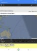
On Monday January 18, I was looking at flights that were taking off via the flight radar 24 app and noticed that
instead of veering out to the East soon after take off, they continued up the coast heading North as if flying onwards to BNE
For example QF 11 did not turn East until approx. Nambucca Heads then headed N.E onwards to LAX
QF 73 headed North until past Brisbane then started heading NE onwards to SFO.
Just curious if this is an ongoing event as I fly Qantas to the US frequently.
On another note, what has caused so many delays with QF73 & 74 since it recommenced last December?
Operational?? Equipment?? Staffing??
Thanks is advance")
On Monday January 18, I was looking at flights that were taking off via the flight radar 24 app and noticed that
instead of veering out to the East soon after take off, they continued up the coast heading North as if flying onwards to BNE
For example QF 11 did not turn East until approx. Nambucca Heads then headed N.E onwards to LAX
QF 73 headed North until past Brisbane then started heading NE onwards to SFO.
Just curious if this is an ongoing event as I fly Qantas to the US frequently.
On another note, what has caused so many delays with QF73 & 74 since it recommenced last December?
Operational?? Equipment?? Staffing??
Thanks is advance