


You are using an out of date browser. It may not display this or other websites correctly.
You should upgrade or use an alternative browser.
You should upgrade or use an alternative browser.
MH 777 missing - MH370 media statement
- Thread starter williamsf1
- Start date
- Status
- Not open for further replies.
whatmeworry
Established Member
- Joined
- Jan 22, 2007
- Posts
- 4,623
Yeah it only touches on the "second plane" but one must wonder why Malaysia airlines didn't attempt communication with the plane and/or sent out planes to investigate.
drron
Veteran Member
- Joined
- Jul 4, 2002
- Posts
- 37,804
Well one from left field-
https://au.news.yahoo.com/sa/a/23036893/exploration-company-believes-it-may-have-found-mh370/
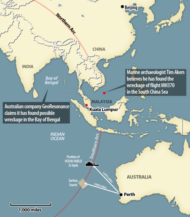
They say it is in the Bay of Bengal.
https://au.news.yahoo.com/sa/a/23036893/exploration-company-believes-it-may-have-found-mh370/
FIRST ON 7: An Adelaide-based exploration company believes it may have located the wreckage of Malaysia Airlines flight MH370, 5000km away from where authorities have been looking.
The company, GeoResonance, says its research has identified elements on the ocean floor consistent with material from a plane
They say it is in the Bay of Bengal.
- Joined
- Nov 12, 2012
- Posts
- 32,777
- Qantas
- Platinum
- Virgin
- Gold
- Star Alliance
- Gold
Well one from left field-
https://au.news.yahoo.com/sa/a/23036893/exploration-company-believes-it-may-have-found-mh370/
They say it is in the Bay of Bengal.
Seem to use nuclear magnetic resonance. Exactly how, in this situation, I'm not sure.
I have a vague feeling I've come across this mob before and its not a positive feeling. Will have to search files.
SMH reports that the disappearance of MH370 may cause the airline to fold. Malaysia Airlines MH370 disappearance may be final straw for airline
SeatBackForward
Senior Member
- Joined
- Jun 20, 2006
- Posts
- 5,785
- Qantas
- LT Gold
- Oneworld
- Emerald
Also, another claim today of a US based pilot finding the wreck off the Thai coast while searching satellite photos.
Pilot claims to have found image of missing MH370
A US pilot believes he has found an image of the wreckage of missing Malaysia Airlines Flight MH370.
Six weeks have now passed since the plane disappeared and extensive searches in the Indian Ocean have failed to locate any wreckage.
New York pilot Michael Hoebel, 60, believes he found an image of what appears to be the wreck of the missing passenger jet in the Gulf of Thailand, which is where the Boeing 777 made its last communication with air traffic authorities on the morning of March 8.
“I was taken aback because I couldn’t believe I would find this,” Hoebel told a local TV news channel after spotting debris he believes perfectly matches the dimensions of the missing plane.
He said he spent hours trawling through thousands of images on TomNod, a crowd-sourcing website that has been sharing online satllite imagery in the hope of finding clues.
Link
browski
Established Member
- Joined
- Sep 8, 2004
- Posts
- 1,498
Also, another claim today of a US based pilot finding the wreck off the Thai coast while searching satellite photos.
It's a shame that Search and Rescue cannot check this out since they are bound by the Inmarsat North and South arc ping theory. Looks promising though. Maybe a few private contractors can rent a tinny/outboard and report back?
SeatBackForward
Senior Member
- Joined
- Jun 20, 2006
- Posts
- 5,785
- Qantas
- LT Gold
- Oneworld
- Emerald
Is it a case that the bluefin cannot detect the wreckage because the ocean floor is deeper than its range?
drron
Veteran Member
- Joined
- Jul 4, 2002
- Posts
- 37,804
Followed up on Georesonance.I doubt the plane is in the Bay of Bengal.
The CEO lives in Sevastopol.Recently Ukrainian now Russian.
Apparently they have used this technology to find a ship that was sunk in WW2 in the Black Sea.They have not found it and the search started several years ago.
The fellow has several patents but only concerning metal detectors.
https://www.metabunk.org/threads/du...onance-believes-it-may-have-found-mh370.3558/
whatmeworry
Established Member
- Joined
- Jan 22, 2007
- Posts
- 4,623
MH370 to be most costly in aviation history.
Malaysia Airlines MH370: Cost pressures mount as search drags on for plane wreckage
Malaysia Airlines MH370: Cost pressures mount as search drags on for plane wreckage
drron
Veteran Member
- Joined
- Jul 4, 2002
- Posts
- 37,804
Prelim reports of investigation-
https://www.documentcloud.org/documents/1151155-mh370-preliminary-report.html
https://www.documentcloud.org/documents/1151152-mh370-actions-taken-between-0138-and-0614l.html
https://www.documentcloud.org/documents/1151153-mh370-cargo-manifest-and-airway-bill.html
https://www.documentcloud.org/documents/1151154-mh370-maps.html
- Joined
- Nov 12, 2012
- Posts
- 32,777
- Qantas
- Platinum
- Virgin
- Gold
- Star Alliance
- Gold
Seem to use nuclear magnetic resonance. Exactly how, in this situation, I'm not sure.
I have a vague feeling I've come across this mob before and its not a positive feeling. Will have to search files.
Followed up on Georesonance.I doubt the plane is in the Bay of Bengal.
The CEO lives in Sevastopol.Recently Ukrainian now Russian.
Apparently they have used this technology to find a ship that was sunk in WW2 in the Black Sea.They have not found it and the search started several years ago.
The fellow has several patents but only concerning metal detectors.
https://www.metabunk.org/threads/du...onance-believes-it-may-have-found-mh370.3558/
I found the presentation I was thinking of. I'm in the mineral exploration business and this was one of things you get sent by colleagues in the "you just won't believe this stuff" category.
It was compiled by "GeoNMR", of the Ukraine.
Example slide of 'How does it work?' (the <<revelation>> is part of the quote):
The first part of our work uses analog satellite space picture of specified territory, which will be activated inside of research nuclear reactor. It is necessary for «revelation» of hide information about required substance
After treatment inside reactor occurs transferring of hidden images by means of special wave scanner and mathematic calculation of results
Gosh!
DrA
Active Member
- Joined
- Jan 25, 2010
- Posts
- 527
I found the presentation I was thinking of. I'm in the mineral exploration business and this was one of things you get sent by colleagues in the "you just won't believe this stuff" category.
It was compiled by "GeoNMR", of the Ukraine.
Example slide of 'How does it work?' (the <<revelation>> is part of the quote):
Gosh!
Also in the mineral exploration business, and using NMR for exploration is a legit method...For things like groundwater exploration or reservoir characterisation. It's got very limited depth penetration (100-150m), and my Google-fu indicates that the Bay of Bengal is on average about 2600m...
I had a look at their website too, and the chronic misuse of geological, geophysical, and remote sensing terminology in general is enough to raise red flags all over the place.
SeatBackForward
Senior Member
- Joined
- Jun 20, 2006
- Posts
- 5,785
- Qantas
- LT Gold
- Oneworld
- Emerald
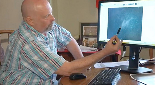
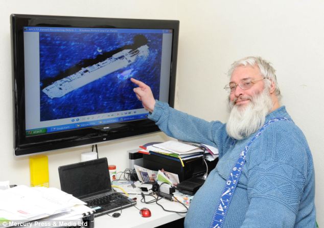
Yet another theory:
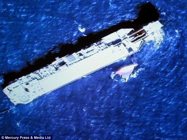
LINKIS THIS MH370'S TAIL? Now UK scientist 'sights' debris painted in MAS colors in area flagged up by US pilot
A British marine archaeologist claims to have found the missing Malaysia Airlines flight MH370 more than 3,000 miles from where authorities are currently searching.
Tim Akers, 56, had been studying Australian waters off Perth for years in a search for the remains of the country's lost WWII ship - the HMAS Sydney.
The search for the vessel was in the same waters that are believed to contain the missing flight MH370 off the coast of Western Australia.
A massive search operation involving satellites, aircraft, ships and sophisticated underwater equipment capable of scouring the ocean floor has failed to turn up any trace of the Boeing 777, which disappeared on March 8.
But Mr Akers, of North Yorkshire now thinks he might have discovered where the flight, carrying 227 passengers and 12 crew, went down after it went missing en route from Kuala Lumpur to Beijing.
He claims to have identified what he believes is part of the tail of the jet off the coast of Vietnam - just around 1,000 miles from where the plane took off.
His findings appear to support reports this week from a US former pilot Michael Hoebel, from New York, who believes he found the wreckage of the flight off the coast of Thailand.
- Joined
- Nov 12, 2012
- Posts
- 32,777
- Qantas
- Platinum
- Virgin
- Gold
- Star Alliance
- Gold
Um, what's that big grey thing next to the supposed tail piece he's pointing to?
eastwest101
Established Member
- Joined
- Oct 26, 2010
- Posts
- 3,468
- Qantas
- Gold
- Virgin
- Silver
Um, what's that big grey thing next to the supposed tail piece he's pointing to?
Looks like an oil/gas exploration/production rig to me, probably photo-shopped in to compare in size for scale? Very dubious source indeed, I would ignore this. About as trustworthy as the Geo-resonance stuff upthread....
If you follow the link and see some of the other images from the M Hoebel images they appear to be rather blurry non-desript pictures of some sort of debris....
Last edited:
As tenuous the link is from geo ... Its being investigated.
http://www.brisbanetimes.com.au/wor...irlines-plane-says-report-20140503-zr3wu.html
http://www.brisbanetimes.com.au/wor...irlines-plane-says-report-20140503-zr3wu.html

Read our AFF credit card guides and start earning more points now.
AFF Supporters can remove this and all advertisements
- Status
- Not open for further replies.


Become an AFF member!
Join Australian Frequent Flyer (AFF) for free and unlock insider tips, exclusive deals, and global meetups with 65,000+ frequent flyers.AFF members can also access our Frequent Flyer Training courses, and upgrade to Fast-track your way to expert traveller status and unlock even more exclusive discounts!
AFF forum abbreviations
Wondering about Y, J or any of the other abbreviations used on our forum?Check out our guide to common AFF acronyms & abbreviations.
Recent Posts
-

-
-
-
Credit Card Offers Qantas Premier Platinum Offers & Discussion
- Latest: wannabeinvestmentbanker
