


You are using an out of date browser. It may not display this or other websites correctly.
You should upgrade or use an alternative browser.
You should upgrade or use an alternative browser.
31 Days to Acadia
- Thread starter OZDUCK
- Start date
- Status
- Not open for further replies.
OZDUCK
Established Member
- Joined
- Aug 1, 2010
- Posts
- 4,822
Anne of Green Gables is exactly why we are going to PEI.Mrsdrron is Ann.
But the mussels particularly along with all the other seafood is what I am sure we will enjoy most.
I was a bit flippant about the "Anne" experience because it doesn't really interest me. However, if you are interested there is no doubt that the Island "does it well". The "Anne" shop in my photo & an "Anne" Chocolate shop are in the main street of Charlottetown. (I admit we weakened and bought chocolates for our daughter & daughter-in-law from that shop.) The musical plays all during the tourist season and gets good reviews. The various birthplaces tourist sites etc are well signposted and appear incredibly well maintained from the outside.
This (fuzzy) photo shows that to find an "Anne" site you just need to follow the signs. To Quote [h=2]"Green Gables Shore Drive (White House)[/h]Follow the white house with green gables around the Green Gables Shore Drive. Probably the most touristy drive on PEI thanks to the wild popularity of the Anne of Green Gables book series."

As regards mussels & seafood below is a seafood chowder - with mussels. Absolute freshest you can get - eaten at

The "Blue Mussel Cafe" in North Rustico Harbour (Fishing boat harbour) - rates 4.6/5 stars in Google Reviews and the same or higher on most sites

My wife also insists that I add this photo. It is of one of the 9 small bronze statues of "Eckhart in The City", a mouse who featured in a popular PEI children's book.They have used the statues as a basis for a scavenger hunt with a little pamphlet giving clues about their locations - which are all in the central city. To findthem you use information about each sites local history. https://www.flickr.com/photos/130308845@N06/sets/72157657430539528.
Originally set up as a summer children's activity but a nice way to enliven your walks.

OZDUCK
Established Member
- Joined
- Aug 1, 2010
- Posts
- 4,822
Around PEI
Cavendish Beach
Lovely Beach - in mid-August water was bracing but would have been swimmable if I had brought my bathers.
The red & white hut is the Lifesavers shed.

Canadian lifesavers and their "tower"

Souros beach - showing the typical PEI red sand.

Greenwich National Park -Floating Boardwalk
The 700 metre boardwalk floats in about 1 metre of water and has anchors chained to it to stop movement.
It is built over a freshwater lake system sheltered behind "a parabolic dune system", and is part of a 4.8k walk from the National Park car-park.
On this walk we saw chipmunks - smaller than we thought - and a snake - almost made me homesick. The owner of the B & B we were
staying in lent us his Annual National Parks Pass.
Looking back from the dunes.

At water level

Cavendish Beach
Lovely Beach - in mid-August water was bracing but would have been swimmable if I had brought my bathers.
The red & white hut is the Lifesavers shed.
Canadian lifesavers and their "tower"
Souros beach - showing the typical PEI red sand.
Greenwich National Park -Floating Boardwalk
The 700 metre boardwalk floats in about 1 metre of water and has anchors chained to it to stop movement.
It is built over a freshwater lake system sheltered behind "a parabolic dune system", and is part of a 4.8k walk from the National Park car-park.
On this walk we saw chipmunks - smaller than we thought - and a snake - almost made me homesick. The owner of the B & B we were
staying in lent us his Annual National Parks Pass.
Looking back from the dunes.
At water level
OZDUCK
Established Member
- Joined
- Aug 1, 2010
- Posts
- 4,822
More Around PEI
Eglise Notre Dame du Mont Carmel in the "Evangline Region" of northern PEI - clusters of Acadian communities.
Beautifully situated on the more sheltered east coast. The Mustang would have been a nice way to tour the island.

French River Fishing Village at North Rustico - one of a number of picturesque fishing villages

I like this idea at the entrance to many of the Canadian beaches. It would also be nice
to personally call out your preferred rescuers name as the rip is taking you off to Greenland.

We seemed to have got a bit lost here.

We saw lots of young girls walking around with the hat and red "braided hair". My Grand-daughter would have liked the Rocking Horse.

Eglise Notre Dame du Mont Carmel in the "Evangline Region" of northern PEI - clusters of Acadian communities.
Beautifully situated on the more sheltered east coast. The Mustang would have been a nice way to tour the island.
French River Fishing Village at North Rustico - one of a number of picturesque fishing villages
I like this idea at the entrance to many of the Canadian beaches. It would also be nice
to personally call out your preferred rescuers name as the rip is taking you off to Greenland.
We seemed to have got a bit lost here.
We saw lots of young girls walking around with the hat and red "braided hair". My Grand-daughter would have liked the Rocking Horse.
Last edited:
OZDUCK
Established Member
- Joined
- Aug 1, 2010
- Posts
- 4,822
Wet weather and food on PEI
Just to prove that we didn't always get perfect weather - but this was the only day in all the time in Canada that we were really restricted
by the weather. And even then it was only for a few hours.

Living in Perth I had never really been convinced by heated seats & steering wheels. I now understand
their attraction - especially in winter in Canada.

After a fairly wild day we couldn't be bothered hunting for a restaurant and just pulled into a chain one -"Swiss Chalet".
(I have no idea why Swiss as there was nothing particularly Swiss about anything they provided)). The meal nearest to the camera is my
wife's spit-grilled beef. It was a 7oz meal - the smallest of the roasted ones and cost about $C21 after tax & tip. You do not often go away hungry after eating out in Canada.

My lunchtime meal at the Blue Mussel Cafe North Rustico. Halibut, caught that morning from a boat operating out of the harbour.
Oven baked with a mango based salsa. One of, if not the, best fish meal I have ever had.

We had waited for about 30 minutes at "The Lobster Shack" and never looked like getting a seat so we gave up and went
back to the main street in Charlottetown and were glad we did. We a lovely meal and excellent service at the Terre Rouge Craft Kitchen -
Terre Rouge. It appears frightfully "hip" but they gave us oldies as much attention as the trendy young things around us. The meal pictured is a combination of their
meat and vegetable tasting plates that they were happy to make up on the spot for us. All the meats & vegetables are locally sourced and fabulously well prepared.
Even the beers are local "craft" products.
As another example of their service I ordered a unusual style beer that the waiter thought I may not like so he bought me a free glass to taste.
He was right and I didn't like it so he simply took that glass away and bought another beer that he recommended , and it was much nicer. For once
adding a tip was a pleasure.

Just to prove that we didn't always get perfect weather - but this was the only day in all the time in Canada that we were really restricted
by the weather. And even then it was only for a few hours.
Living in Perth I had never really been convinced by heated seats & steering wheels. I now understand
their attraction - especially in winter in Canada.
After a fairly wild day we couldn't be bothered hunting for a restaurant and just pulled into a chain one -"Swiss Chalet".
(I have no idea why Swiss as there was nothing particularly Swiss about anything they provided)). The meal nearest to the camera is my
wife's spit-grilled beef. It was a 7oz meal - the smallest of the roasted ones and cost about $C21 after tax & tip. You do not often go away hungry after eating out in Canada.
My lunchtime meal at the Blue Mussel Cafe North Rustico. Halibut, caught that morning from a boat operating out of the harbour.
Oven baked with a mango based salsa. One of, if not the, best fish meal I have ever had.
We had waited for about 30 minutes at "The Lobster Shack" and never looked like getting a seat so we gave up and went
back to the main street in Charlottetown and were glad we did. We a lovely meal and excellent service at the Terre Rouge Craft Kitchen -
Terre Rouge. It appears frightfully "hip" but they gave us oldies as much attention as the trendy young things around us. The meal pictured is a combination of their
meat and vegetable tasting plates that they were happy to make up on the spot for us. All the meats & vegetables are locally sourced and fabulously well prepared.
Even the beers are local "craft" products.
As another example of their service I ordered a unusual style beer that the waiter thought I may not like so he bought me a free glass to taste.
He was right and I didn't like it so he simply took that glass away and bought another beer that he recommended , and it was much nicer. For once
adding a tip was a pleasure.
OZDUCK
Established Member
- Joined
- Aug 1, 2010
- Posts
- 4,822
Cape Breton Island
After 4 nights we headed off to Cape Breton. As I said in another post you can use either the ferry or bridge to get off the PEI. We had planned to use the ferry which, while no faster due to waiting, loading time etc, would have cut a few hundred km off our trip. Unfortunately, one of the two ferries on the run needed urgent repairs and was out of action for several months. So we took the bridge and had a long drive to our first stop on Cape Breton - Port Hood. Driving around Cape Breton was the slowest we traveled because the roads, while usually well made, are narrow and twisty with lots of hills - especially in the north of the Island.
The causeway to cape Breton Island (CBI on the left)

Sunset at Mabou

The same body of water, from a slightly higher point, the next day

Starting the drive through the Cape Breton Highlands National Park on the "Cabot Trail".

After 4 nights we headed off to Cape Breton. As I said in another post you can use either the ferry or bridge to get off the PEI. We had planned to use the ferry which, while no faster due to waiting, loading time etc, would have cut a few hundred km off our trip. Unfortunately, one of the two ferries on the run needed urgent repairs and was out of action for several months. So we took the bridge and had a long drive to our first stop on Cape Breton - Port Hood. Driving around Cape Breton was the slowest we traveled because the roads, while usually well made, are narrow and twisty with lots of hills - especially in the north of the Island.
The causeway to cape Breton Island (CBI on the left)
Sunset at Mabou
The same body of water, from a slightly higher point, the next day
Starting the drive through the Cape Breton Highlands National Park on the "Cabot Trail".
Attachments
earlyriser
Member
- Joined
- Jul 6, 2015
- Posts
- 476
Stunning sunset pic!
OZDUCK
Established Member
- Joined
- Aug 1, 2010
- Posts
- 4,822
Stunning sunset pic!
Thanks, we were there at just the right time.A couple more for you.
Mabou is home to the"Red Shoe Pub - famous for the"Fiddle"music played there.We were going to stay for the music but my wife felt
unwell so went back to our B&B. And then had to listen to all the other guests at breakfast saying what a great show it had been.


Elevate your business spending to first-class rewards! Sign up today with code AFF10 and process over $10,000 in business expenses within your first 30 days to unlock 10,000 Bonus PayRewards Points.
Join 30,000+ savvy business owners who:
✅ Pay suppliers who don’t accept Amex
✅ Max out credit card rewards—even on government payments
✅ Earn & transfer PayRewards Points to 10+ airline & hotel partners
Start earning today!
- Pay suppliers who don’t take Amex
- Max out credit card rewards—even on government payments
- Earn & Transfer PayRewards Points to 8+ top airline & hotel partners
AFF Supporters can remove this and all advertisements
OZDUCK
Established Member
- Joined
- Aug 1, 2010
- Posts
- 4,822
Skyline Trail - walking Track off the Cabot Trail
What to do if confronted by coyotes - my preferred option of running away screaming is not recommended.
Unfortunately, a female walker was killed here by a pack about 9 years ago.

bears and coyotes and moose - oh my!

My wife decided this was far enough. The last few hundred metres are virtually straight down. The only wooden steps on the track.

Looking back up from the actual end.

Just to prove that, despite folklore, Canadians don't always obey the rules.

What to do if confronted by coyotes - my preferred option of running away screaming is not recommended.
Unfortunately, a female walker was killed here by a pack about 9 years ago.
bears and coyotes and moose - oh my!
My wife decided this was far enough. The last few hundred metres are virtually straight down. The only wooden steps on the track.
Looking back up from the actual end.
Just to prove that, despite folklore, Canadians don't always obey the rules.
OZDUCK
Established Member
- Joined
- Aug 1, 2010
- Posts
- 4,822
More of the Cabot Trail
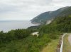
Looking back from the Skyline Trail towards Cheticamp - about 8km

Looking towards "Old Smokey". The road goes over the top - via a lot of switchbacks - and is an "interesting" drive.

On Cape Breton Gaelic is often the second language

Neil's Harbour

Heading towards Sydney we used this cable ferry at Little Narrows to cut off a lot of km of driving around a bay.
The bay is only a couple of hundred metres wide here. The trip only takes about 5 minutes and costs C$7.
The ferry takes 10 cars and we only had to wait for 1 sailing. On the other side of the narrows there were 50 or 60 cars queued up and more coming.

Looking back from the Skyline Trail towards Cheticamp - about 8km
Looking towards "Old Smokey". The road goes over the top - via a lot of switchbacks - and is an "interesting" drive.
On Cape Breton Gaelic is often the second language
Neil's Harbour
Heading towards Sydney we used this cable ferry at Little Narrows to cut off a lot of km of driving around a bay.
The bay is only a couple of hundred metres wide here. The trip only takes about 5 minutes and costs C$7.
The ferry takes 10 cars and we only had to wait for 1 sailing. On the other side of the narrows there were 50 or 60 cars queued up and more coming.
OZDUCK
Established Member
- Joined
- Aug 1, 2010
- Posts
- 4,822
Sydney and Louisbourg
We only spent 2 days and 1 night on the Cabot Trail. It was really not enough but we we definitely wanted to have a good look at the Fortress of Louisbourg
and you only have so much time on even a long vacation.
Sydney was the former colonial capital city but when Cape Breton was amalgamated with Nova Scotia Halifax became the capital. It has
a population of about 32,000 and has a faded air about it. It used to be home to a large steel mill and coal workings - closed 2001.
During WW2, Sydney was a major assembly point for the Atlantic Convoys. This is a rather poignant memorial to the Merchant Marine. Purely by accident
I think I got the sun in the right spot.

It is also home to "the worlds largest fiddle". Is it better than a "Big Prawn" or "Big Pineapple"?

There are some nice leafy streets but I still sensed a bit of "sadness' in the town.

We then spent a couple of nights in Louisbourg.
One view from the balcony of our room

Looking the other way was the reason we had come. The Fortress of Louisbourg

We only spent 2 days and 1 night on the Cabot Trail. It was really not enough but we we definitely wanted to have a good look at the Fortress of Louisbourg
and you only have so much time on even a long vacation.
Sydney was the former colonial capital city but when Cape Breton was amalgamated with Nova Scotia Halifax became the capital. It has
a population of about 32,000 and has a faded air about it. It used to be home to a large steel mill and coal workings - closed 2001.
During WW2, Sydney was a major assembly point for the Atlantic Convoys. This is a rather poignant memorial to the Merchant Marine. Purely by accident
I think I got the sun in the right spot.
It is also home to "the worlds largest fiddle". Is it better than a "Big Prawn" or "Big Pineapple"?
There are some nice leafy streets but I still sensed a bit of "sadness' in the town.
We then spent a couple of nights in Louisbourg.
One view from the balcony of our room
Looking the other way was the reason we had come. The Fortress of Louisbourg
OZDUCK
Established Member
- Joined
- Aug 1, 2010
- Posts
- 4,822
More Of Louisbourg
These are a couple of photos taken by my wife on her phone from the balcony . The sea fog does make a slight difference.
My wife made me pay an extra 30 odd dollars for the "sea-view" room and she was right.
Beautiful one day

Not quite so good the next

For those who like some big American cars - a selection including a Ford Mercury & Chrysler LeBaron

We visited the fortress on a foggy and wet day and it probably added in giving it a bit of an "outpost" feeling.
The Fortress, and not Fort, was built by the French between 1720 - 1740 and was twice captured by the British and demolished by them in 1758. It was badly sited with high ground at its rear.
It was partially reconstructed, about a quarter, in the 1960's & 70's as a employment project for coal miners, as that industry was devastated by supplies of cheap coal from places like Australia.
It is now run as a "Living Museum" with re-enactors populating the Fortress in the summer months.
My wife and I at the gates - she was wondering about the "in-character" mutterings by the locals. I had to point out that she was wearing the dreaded "English" red and that the Seven years War was still on here!

A nice atmospheric view of the waterfront.

These are a couple of photos taken by my wife on her phone from the balcony . The sea fog does make a slight difference.
My wife made me pay an extra 30 odd dollars for the "sea-view" room and she was right.
Beautiful one day
Not quite so good the next
For those who like some big American cars - a selection including a Ford Mercury & Chrysler LeBaron
We visited the fortress on a foggy and wet day and it probably added in giving it a bit of an "outpost" feeling.
The Fortress, and not Fort, was built by the French between 1720 - 1740 and was twice captured by the British and demolished by them in 1758. It was badly sited with high ground at its rear.
It was partially reconstructed, about a quarter, in the 1960's & 70's as a employment project for coal miners, as that industry was devastated by supplies of cheap coal from places like Australia.
It is now run as a "Living Museum" with re-enactors populating the Fortress in the summer months.
My wife and I at the gates - she was wondering about the "in-character" mutterings by the locals. I had to point out that she was wearing the dreaded "English" red and that the Seven years War was still on here!
A nice atmospheric view of the waterfront.
OZDUCK
Established Member
- Joined
- Aug 1, 2010
- Posts
- 4,822
Fortress of Louisbourg
As with all the "historic sites" we visited in Canada a lot of effort is made to explain the why and wherefores and specific significance of each site. The use of re-enactors is done very well, they are often Uni. students on their summer break. Talking to them they enjoy their work and often will do it for a number of years. They are given a lot of training and will talk to you about how their character would have lived and worked etc.
It was emphasised that this was a fortress and not a fort - the difference being that a fort was just to "hold" some particular point where a fortress enable people to live and work and develop an area.
Some of the "locals" dressed very convincingly


Children being shown how to prepare salt cod - the main activity of the original settlers. The coloured plastic pieces in the basket are the innards and spine of the model cod.
As you would guess, the kids were having a great time.

The "locals" enjoying an afternoon dance - accompanied on a harpsichord. It is mostly done in character with the two "brothers" complaining about each others wives, spendthrift ways etc.
There are pauses for questions and we were surprised to learn that the women in the original colony were obtaining the latest Paris fashions within 4 weeks - depending on the weather.n.
The dresses were "cut" in France and sent unstitched over in such a way that a local seamstress could fit the dress to a particular customer.

They fire a gun twice a day with pipes and drummers in attendance.

As with all the "historic sites" we visited in Canada a lot of effort is made to explain the why and wherefores and specific significance of each site. The use of re-enactors is done very well, they are often Uni. students on their summer break. Talking to them they enjoy their work and often will do it for a number of years. They are given a lot of training and will talk to you about how their character would have lived and worked etc.
It was emphasised that this was a fortress and not a fort - the difference being that a fort was just to "hold" some particular point where a fortress enable people to live and work and develop an area.
Some of the "locals" dressed very convincingly
Children being shown how to prepare salt cod - the main activity of the original settlers. The coloured plastic pieces in the basket are the innards and spine of the model cod.
As you would guess, the kids were having a great time.
The "locals" enjoying an afternoon dance - accompanied on a harpsichord. It is mostly done in character with the two "brothers" complaining about each others wives, spendthrift ways etc.
There are pauses for questions and we were surprised to learn that the women in the original colony were obtaining the latest Paris fashions within 4 weeks - depending on the weather.n.
The dresses were "cut" in France and sent unstitched over in such a way that a local seamstress could fit the dress to a particular customer.
They fire a gun twice a day with pipes and drummers in attendance.
OZDUCK
Established Member
- Joined
- Aug 1, 2010
- Posts
- 4,822
More of the Fortress
Buildings on the waterfront

The main building which contained the soldiers barracks, Governors Rooms etc

View of the town across a vegetable garden which is planted in 18th Century fashion

The period smithy - he was making roses with petals

One final view from across the bay.

Buildings on the waterfront
The main building which contained the soldiers barracks, Governors Rooms etc
View of the town across a vegetable garden which is planted in 18th Century fashion
The period smithy - he was making roses with petals
One final view from across the bay.
OZDUCK
Established Member
- Joined
- Aug 1, 2010
- Posts
- 4,822
Last of Louisbourg
We stayed at the "Point of View Suites" which is, as you have seen, is right on the waterfront. We took a package deal which got us the room with breakfast, entrance to the fortress and tickets to "The Beggars Banquet". This is a meal and show put on at the suites.
Basically you get fitted with 18th Century clothes (over your own) have a meal of Lobster/Fish/Chicken plus starters and desserts. There is a performer - of Acadian descent - who sings both newer and old songs. There are also cast members who roam through the crowd. It is a fun night and - if not overlong - about 2 1/2 hours.
It sounds very "touristy" - which it is but still good fun and after all we were tourists.. Have a look at TripAdvisor and you see it rates 4.5/5 stars.
The main accommodation block. We had the top left room - huge studio apartment with Queen Bed, kitchen, sofa etc - stairs were a little steep and if it blew you certainly felt the wind on the balcony. We paid C$439 for 2 nights including all the extras.

My wife's Lobster Meal - before and after. She said that it didn't have the strong taste of our W.A. Crayfish. I had only a small taste as I hate crayfish and it did seem a bit blander to me.


Our table. we had meet the older couple at our previous B&B on the Cabot Trail and when we found out we had booked the same deal for Louisbourg we agreed to meet up for the meal.
Afterwards we went to our room for coffee and it was nice to have a chat with the "locals". They were from Winnipeg and the weather there would put me off -with a mean winter low of
-17C to a mean summer high of 20C and bursts in the minus 30's to plus 30's. She worked as a nurse in a first nations community north of Winnipeg and it was sad to hear
of the same problems there as in many of our aboriginal communities - drugs, alcohol, violence, suicide etc.

The younger couple lived in Montreal - she was from France. She confirmed that the performer was singing traditional French country songs,
some that she had last heard at fairs in her village in Picardy.

We stayed at the "Point of View Suites" which is, as you have seen, is right on the waterfront. We took a package deal which got us the room with breakfast, entrance to the fortress and tickets to "The Beggars Banquet". This is a meal and show put on at the suites.
Basically you get fitted with 18th Century clothes (over your own) have a meal of Lobster/Fish/Chicken plus starters and desserts. There is a performer - of Acadian descent - who sings both newer and old songs. There are also cast members who roam through the crowd. It is a fun night and - if not overlong - about 2 1/2 hours.
It sounds very "touristy" - which it is but still good fun and after all we were tourists.. Have a look at TripAdvisor and you see it rates 4.5/5 stars.
The main accommodation block. We had the top left room - huge studio apartment with Queen Bed, kitchen, sofa etc - stairs were a little steep and if it blew you certainly felt the wind on the balcony. We paid C$439 for 2 nights including all the extras.
My wife's Lobster Meal - before and after. She said that it didn't have the strong taste of our W.A. Crayfish. I had only a small taste as I hate crayfish and it did seem a bit blander to me.
Our table. we had meet the older couple at our previous B&B on the Cabot Trail and when we found out we had booked the same deal for Louisbourg we agreed to meet up for the meal.
Afterwards we went to our room for coffee and it was nice to have a chat with the "locals". They were from Winnipeg and the weather there would put me off -with a mean winter low of
-17C to a mean summer high of 20C and bursts in the minus 30's to plus 30's. She worked as a nurse in a first nations community north of Winnipeg and it was sad to hear
of the same problems there as in many of our aboriginal communities - drugs, alcohol, violence, suicide etc.
The younger couple lived in Montreal - she was from France. She confirmed that the performer was singing traditional French country songs,
some that she had last heard at fairs in her village in Picardy.
OZDUCK
Established Member
- Joined
- Aug 1, 2010
- Posts
- 4,822
Wolfville
After a couple of lovely nights in Louisbourg we took a long drive of about 6 hours to Wolfville - in the Annapolis Valley area of western Nova Scotia.
This photo gives an idea of the size of the Bras d'Or Lake which occupies a large part of Cape Breton Island.

View from the "The Look Off" - which looks out over part of the very fertile Annapolis Valley. The water is the "Minas Basin" and Wolfville is just to the right of the top of the photo. The lands around the waters edge were reclaimed from salt marshes by our old friend the Acadians from 1680 -1755. They used a system of dykes and sluices to protect the land from the massive Bay of Fundy tides and then slowly wash the salt out of the soil.

This photo shows the huge areas of mud that surround Minas basin at low tide.

This is the memorial church at the Grand-Pré National Historic Site which is a World Heritage Site. It "is a park set aside to commemorate the Grand-Pré area of Nova Scotia as a centre of Acadian settlement from 1682 to 1755, and the British deportation of the Acadians that happened during the French and Indian War." The statue in front of the church is of Evangeline - "Evangeline, A Tale of Acadie, is an epic poem by the American poet Henry Wadsworth Longfellow, written in English and published in 1847. The poem follows an Acadian girl named Evangeline and her search for her lost love Gabriel, set during the time of the Expulsion of the Acadians." There is now and "Evangeline Trail" which runs through the Annapolis Valley and covers sites connected to the Acadians.

This from a lookout hill at Grand-Pré. You can just see the memorial church spire in the foreground, amongst the trees. The cough lands run out to the water. The drained lands were about 3 metres below the high tide water level. The red "adirondack chairs" are a common sight throughout Canada at scenic viewpoints and are placed there by Parks Canada

After a couple of lovely nights in Louisbourg we took a long drive of about 6 hours to Wolfville - in the Annapolis Valley area of western Nova Scotia.
This photo gives an idea of the size of the Bras d'Or Lake which occupies a large part of Cape Breton Island.
View from the "The Look Off" - which looks out over part of the very fertile Annapolis Valley. The water is the "Minas Basin" and Wolfville is just to the right of the top of the photo. The lands around the waters edge were reclaimed from salt marshes by our old friend the Acadians from 1680 -1755. They used a system of dykes and sluices to protect the land from the massive Bay of Fundy tides and then slowly wash the salt out of the soil.
This photo shows the huge areas of mud that surround Minas basin at low tide.
This is the memorial church at the Grand-Pré National Historic Site which is a World Heritage Site. It "is a park set aside to commemorate the Grand-Pré area of Nova Scotia as a centre of Acadian settlement from 1682 to 1755, and the British deportation of the Acadians that happened during the French and Indian War." The statue in front of the church is of Evangeline - "Evangeline, A Tale of Acadie, is an epic poem by the American poet Henry Wadsworth Longfellow, written in English and published in 1847. The poem follows an Acadian girl named Evangeline and her search for her lost love Gabriel, set during the time of the Expulsion of the Acadians." There is now and "Evangeline Trail" which runs through the Annapolis Valley and covers sites connected to the Acadians.
This from a lookout hill at Grand-Pré. You can just see the memorial church spire in the foreground, amongst the trees. The cough lands run out to the water. The drained lands were about 3 metres below the high tide water level. The red "adirondack chairs" are a common sight throughout Canada at scenic viewpoints and are placed there by Parks Canada
Last edited:


OZDUCK
Established Member
- Joined
- Aug 1, 2010
- Posts
- 4,822
Wolfville
Woolfville is a pleasant town and is a good base for exploring around this part of Nova Scotia. It is a university town with a year-round population of just over 4,000 which nearly doubles when Acadia (again) University students take up residence. However, in itself it is not a highlight of the area. Apart from shorelines and Acadian history this is a major up-and-coming wine making area. Think Margaret River 20 years ago. There are some nice vineyards around and we bought a few bottle to bring home - they also make an "Ice Wine" like the more famous ones from around Niagara.
Below are a last few photos of the area.
A 4-way stop sign in the centre of town. I eventually got used to these and the "first car there has right of way" principal.
However, the moment the traffic gets a bit heavy it seems to break down - as can be seen in the second photo with the long queue for the stop sign. There are only
a few roundabouts in the Canadian roads I travelled and it is obvious that the locals are very hesitant about how to use them. Talking
to them they say that they are still very new and a "bit confusing". When they go to Europe they must really struggle!


You know you are in a different sports culture when you see these places.

A beer "taster-plate" at a "Gastro Pub", the Port Pub (www.theportpub.com) which also brews their own beers, just out of town at Port Williams.
The missing glass is because they had run out of that variety - so they let me choose whichever one I liked best as a replacement.
I must admit that I wasn't that keen on them as they were mostly variations on Pale ales, Red Ales etc - which are not my favourite style of beer.
But it was pretty good value at $5.99 (before tax & tip of course) - I think they were 250ml glasses. The food we had was nice and it is in a interesting pub in an port location on a tidal river.

There is loads of accommodation in around Wolfville - because it is a major tourism area and because of the university.We had something like a "Teenagers Retreat"
in the back garden which had twin beds & en-suite with a private entrance through the lovely garden. Each morning we had breakfast on this patio under the
ripening grapes - it was a lovely way to start the day

Woolfville is a pleasant town and is a good base for exploring around this part of Nova Scotia. It is a university town with a year-round population of just over 4,000 which nearly doubles when Acadia (again) University students take up residence. However, in itself it is not a highlight of the area. Apart from shorelines and Acadian history this is a major up-and-coming wine making area. Think Margaret River 20 years ago. There are some nice vineyards around and we bought a few bottle to bring home - they also make an "Ice Wine" like the more famous ones from around Niagara.
Below are a last few photos of the area.
A 4-way stop sign in the centre of town. I eventually got used to these and the "first car there has right of way" principal.
However, the moment the traffic gets a bit heavy it seems to break down - as can be seen in the second photo with the long queue for the stop sign. There are only
a few roundabouts in the Canadian roads I travelled and it is obvious that the locals are very hesitant about how to use them. Talking
to them they say that they are still very new and a "bit confusing". When they go to Europe they must really struggle!
You know you are in a different sports culture when you see these places.
A beer "taster-plate" at a "Gastro Pub", the Port Pub (www.theportpub.com) which also brews their own beers, just out of town at Port Williams.
The missing glass is because they had run out of that variety - so they let me choose whichever one I liked best as a replacement.
I must admit that I wasn't that keen on them as they were mostly variations on Pale ales, Red Ales etc - which are not my favourite style of beer.
But it was pretty good value at $5.99 (before tax & tip of course) - I think they were 250ml glasses. The food we had was nice and it is in a interesting pub in an port location on a tidal river.
There is loads of accommodation in around Wolfville - because it is a major tourism area and because of the university.We had something like a "Teenagers Retreat"
in the back garden which had twin beds & en-suite with a private entrance through the lovely garden. Each morning we had breakfast on this patio under the
ripening grapes - it was a lovely way to start the day
OZDUCK
Established Member
- Joined
- Aug 1, 2010
- Posts
- 4,822
Annapolis Royal
The area around Annapolis Royal was first settled around 1605 - so there is a bit of history here. The town itself was attacked 13 times by the French and British as it changed hands during the various wars - including an attack during the American Revolution. This makes it the most attacked place in North America. The historic centre is a designated National Historic site of Canada.
Looking across the remains of Fort Anne at Annapolis Royal. It was first built in 1634 and rebuilt 4 times, the last time being in 1702. It was built in a classic "Vauban" star-shaped earthworks format. (Vauban was Louis XIV's - the Sun King - famous military engineer).The fort has a commanding view over the Annapolis basin. Also notice the ubiquitous Okanagan Chairs.

Another view of the fort. The Powder Room is in the foreground.

We took a "candlelight" tour of the historic cemetery - the oldest English graveyard in Canada with headstones dating back to 1720 - attached to the fort. It is not a "ghost tour" - and all the better because of that. It has been run for 23 years, seven nights a week by just one local historian. He said he had missed 3 nights in that time because of electrical storms. (In line with this trip he is naturally of Acadian descent.) Deservedly rated 5 stars on TripAdvisor.

The fort from across the basin.

They take their history seriously here

The area around Annapolis Royal was first settled around 1605 - so there is a bit of history here. The town itself was attacked 13 times by the French and British as it changed hands during the various wars - including an attack during the American Revolution. This makes it the most attacked place in North America. The historic centre is a designated National Historic site of Canada.
Looking across the remains of Fort Anne at Annapolis Royal. It was first built in 1634 and rebuilt 4 times, the last time being in 1702. It was built in a classic "Vauban" star-shaped earthworks format. (Vauban was Louis XIV's - the Sun King - famous military engineer).The fort has a commanding view over the Annapolis basin. Also notice the ubiquitous Okanagan Chairs.
Another view of the fort. The Powder Room is in the foreground.
We took a "candlelight" tour of the historic cemetery - the oldest English graveyard in Canada with headstones dating back to 1720 - attached to the fort. It is not a "ghost tour" - and all the better because of that. It has been run for 23 years, seven nights a week by just one local historian. He said he had missed 3 nights in that time because of electrical storms. (In line with this trip he is naturally of Acadian descent.) Deservedly rated 5 stars on TripAdvisor.
The fort from across the basin.
They take their history seriously here
- Status
- Not open for further replies.


Become an AFF member!
Join Australian Frequent Flyer (AFF) for free and unlock insider tips, exclusive deals, and global meetups with 65,000+ frequent flyers.AFF members can also access our Frequent Flyer Training courses, and upgrade to Fast-track your way to expert traveller status and unlock even more exclusive discounts!
AFF forum abbreviations
Wondering about Y, J or any of the other abbreviations used on our forum?Check out our guide to common AFF acronyms & abbreviations.
